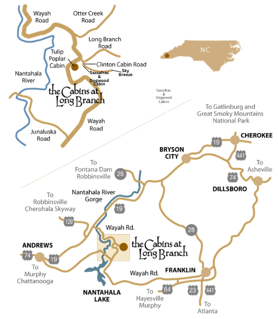
Scroll To Top

Where Are The Cabins?

Vacation Cabins atop Nantahala Mountain. Secluded and near everything you want to do.

The Cabins at Long Branch are located in the Nantahala community near Andrews, Franklin and Bryson City, NC - about 2.5 hours north of Atlanta, 1.5 hours east of Chattanooga and 1.5 hours west of Asheville.

CAN I USE GPS NAVIGATION?

Yes. But because there's little or no cell service along Wayah Road, when using Google or Apple maps, you should load the directions into your mobile device while you have a strong signal.

For Dogwood and Sassafras, these GPS coordinates provide directions to the Long Branch Road turn off of Wayah Road. From there, go .2 miles, turn right on Clinton Cabin Road.

GPS: 35.238049, -83.626096  

Google Maps

Apple Maps


For Tulip Poplar, these GPS coordinates provide directions to the cabin on Wayah Road.

GPS: 35.235769, -83.628406

Google Maps

Apple Maps

Location

From Andrews or Bryson City, you'll travel Hwy 19/74 to Wayah Road (NC 1310) and proceed 5.5 miles north to Long Branch Road.

Shortly after turning onto Wayah Road, you'll see the main rafting put-in area on your left – the beginning of the eight-mile whitewater course that draws thousands to the Nantahala each summer. On your right is the Nantahala power plant, which regulates the river's flow ensuring great rafting even during the dryer summer months.

There are two trails nearby. The famous Bartram trail passes just west of the power plant. And from the launch site, you can cross a footbridge to a easy walking trail beside the river.

The drive up the mountain to the cabins is spectacular, following the scenic Upper Nantahala River most of the way. There are numerous waterfalls and cascades. And chances are you'll see fly fishermen wading the river along the way.

Complete addresses, phone numbers at the cabins and driving instructions will be provided once your reservations are completed.

From Franklin, you'll take Wayah Road all the way. Atop Wayah Mountain, look for the sign to the Wayah Bald Observation Tower. The stone tower (5,342 feet) was built by the Civilian Conservation Corps in 1937 for fire detection and offers a spectacular view. The Appalachian Trail and Bartram Trail cross at Wayah Bald.

Continuing on Wayah Road, you'll pass Nantahala Lake and the Lakes End Marina and Grill. From there, it's another 4.5 miles to Long Branch Road.

Complete addresses, phone numbers at the cabins and driving instructions will be provided once your reservations are completed.

Smoky Mountain High

Our cabins are located on property with elevations of over 3500 feet – so summers are cool and winters are snowy. Note: In the winter, 4-wheel drive may be required.

Following are the elevations of some familiar locations. Summer temperatures in the mountains frequently will be five degrees lower for each 500 feet elevation increase.

Lowest elevation in Great Smoky Mtns National Park 840 ft
Gatlinburg, TN 1300 ft
Andrews, NC 1700 ft
Blue Ridge, GA 1710 ft
Cades Cove, TN 1750 ft
Cherokee, NC 1990 ft
Asheville, NC 2000 ft
The Cabins at Long Branch 3500 ft
Wayah Bald (nearby scenic mountain top) 5342 ft
Clingman's Dome (highest point in Smokies) 6500 ft
Mt. Mitchell, NC (highest point in eastern U.S.) 6684 ft